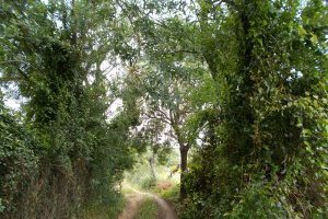
Through the São Cucufate Vineyards
Code: VDG PR1
Geographical location: Vidigueira
Type: Circular walk
Main themes: Rurality, Cultural Heritage, Scenery
Distance: 17.9 km
Approximate duration: 5 to 6 hours
Type of surface: Country and city paths, secondary roads
Ascent/descent: 268 m
Minimum altitude: 179 m
Maximum altitude: 308 m
Level of difficulty: Medium
Certifications: Approved by the FPCM (Portuguese Camping and Mountaineering Federation)
Start and finish: Praça da República, Vidigueira
Geographical coordinates: N38º12'33'' W07º48'00''
Geographical coordinates: 38.209400º -7.800218
Where to park: Parking available in the immediate vicinity, within the built-up area.
Useful Contacts:
Vidigueira Tourist OfficeTelephone: +351 284 437 410
E-mail: museu@cm-vidigueira.pt
This is the land of small vineyards, rented plots of Crown land, and the ancient skills and knowledge of monks and farmers. Sheltered from the north winds by the uplands of Portel and Mendro, the fertile lands in the valley became home to various civilisations whose historical legacy lives on in the town of São Cucufate. Following on the heels of the Romans came the skilful convent crafts that have survived to the present day, in the form of wine produced in earthenware vats, olive oil and even locally-grown oranges in the land was once the County of Vasco da Gama.


