Along the Odelouca Stream
Code: ADV PR6
Geographical location: São Barnabé, Almodôvar
Type: Circular walk
Main themes: Nature, upland scenery, streams
Distance: 9.50 km
Approximate duration: 3 to 4 hours
Type of surface: Country and forest paths
Ascent/descent: 408 m
Minimum altitude: 234 m
Maximum altitude: 451 m
Level of difficulty: Medium
Certifications: Approved by the FPCM (Portuguese Camping and Mountaineering Federation)
Start and finish: Igreja Matriz (Main Church) of São Barnabé (Saint Barnabas), Almodôvar
Geographical coordinates: N37º21'26"" W08º09'55''
Geographical coordinates: 37.357246º -8.165382º
Where to park: Public car park at the site
Useful Contacts:
Almodôvar Tourist Board
Telephone: +351 286 662 057
E-mail: turismo@cm-almodovar.pt
Almodôvar’s vast territory is a mystery waiting to be explored, in terms of both its geography and its history. People have lived here since the Neolithic period, and stones engraved with Southwest Script have been found here, taking us back 2,500 years into the past, to a time when stone was the support for the written word. Various civilisations have been responsible for shaping Almodôvar’s identity; crossing the Serra do Caldeirão uplands, they gave rise to hamlets such as São Barnabé, known as the capital of medronho, the famous brandy made from the fruit of the strawberry tree.
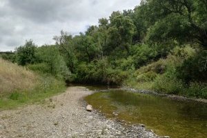
This is a route which takes you through expansive uplands and deep valleys carved out by torrential water courses and by the Odelouca stream, the central focus of a terrain marked by peaks that afford scenic views for as far as the eye can see.


