Campo Maior
Code: CMR PR4
Geographical location: Campo Maior
Type: Circular walk
Main themes: Military defences, archaeology, scenery
Distance: 7.5 km
Approximate duration: 2 to 3 hours
Type of surface: Country and city paths
Ascent/descent: 285 m
Minimum altitude: 261 m
Maximum altitude: 316 m
Level of difficulty: Medium
Certifications: Approved by the FPCM (Portuguese Camping and Mountaineering Federation)
Start and finish: Largo do Barata, Campo Maior
Geographical coordinates: N39º00'46'' W07º04'20''
Geographical coordinates: 39.012864º -7.072393º
Where to park: Parking available in the immediate vicinity, within the built-up area.
Useful Contacts:
- Campo Maior Tourist Board
- Telephone: +351 268 689 367
- E-mail: turismo@cm-campo-maior.pt
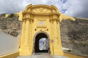
Being in Campo Maior is like breathing centuries of fights and battles, now finally dormant in the ancient memory of its walls, defensive structures, barracks and castle. Legend has it that after the prehistoric and Roman occupations, it was the Moors who built the first city, Christianised in the early thirteenth century by people from neighbouring Badajoz in the kingdom of Castile. A borderland between the kingdoms of Portugal and Castile, it was forced to build a history of defences and contraband encompassing the now-peaceful fields that stretch for as far as the eye can see.
The route, which is both tranquil and accessible, helps you to relive spaces and moments in the town centre, in the ravelins and exterior walls and in the now-peaceful surrounding fields, which marked so many struggles in the past. Here too, you experience the peacefulness of the first Portuguese saint, ever-present in the memory of the people and the spaces.


